Difference between revisions of "CEDEUS CSW"
From stgo
| Line 1: | Line 1: | ||
>> return to [[Cedeus IDE]] | >> return to [[Cedeus IDE]] | ||
---- | ---- | ||
| − | There exists two options to retrieve metadata | + | There exists two options to retrieve metadata from GeoNode: |
* using OGC CSW standard, and | * using OGC CSW standard, and | ||
* using the GeoNode - Django API. | * using the GeoNode - Django API. | ||
| + | |||
=== Using GeoNode CSW === | === Using GeoNode CSW === | ||
Revision as of 16:32, 5 October 2016
>> return to Cedeus IDE
There exists two options to retrieve metadata from GeoNode:
- using OGC CSW standard, and
- using the GeoNode - Django API.
Using GeoNode CSW
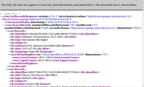
Geonode comes with pyCSW installed (see FAQ pyCSW). A request can look like that:
http://datos.cedeus.cl/catalogue/csw?service=CSW&version=2.0.2&request=GetRecords&typenames=csw:Record&elementsetname=full&resulttype=
As one can see the results include spatial and non-spatial records (i.e. the first document below is a pdf). Another option is to use a CSW plugin for GeoServer (but this is of course not installed for GeoNode).
Using GeoNode API
when using the Search field of GeoNode an API request is done. However, unfortunately the response seems to be a html document. So, I am not sure we can use this for a search from a remote website.
A GET request (as send from the search field) looks like this:
http://datos.cedeus.cl/search/api?type=all&limit=10&sort=none&start=0&q=Copiapo
And the response starts like this:
{"success": true, "facets": {"map": 0, "layer": 2, "raster": 1, "vector": 1, "user": 0, "document": 0},
"results": [{"category": "imageryBaseMapsEarthCover", "rating": 0.0, "_type": "layer", "name": "cediz-images:COPIAPO", "links": ...
