Difference between revisions of "FOS GIS Software Map"
From stgo
m |
|||
| (12 intermediate revisions by one user not shown) | |||
| Line 1: | Line 1: | ||
| − | + | * The general overview page: [[Open Source GIS Software]] | |
| + | * The software list itself: [[FOSS4G Software List]] | ||
| − | + | ---- | |
| − | + | ||
| + | Software that needs to be checked / was checked for inclusion: | ||
| + | |||
| + | Projects that need '''to be checked''' for the list: | ||
* eventually: | * eventually: | ||
| − | ** webdev: | + | ** webdev: MS DeepZoom/DeepEarth |
| − | ** database/DBMS: | + | ** database/DBMS: --- |
| − | ** metadata: | + | ** metadata: --- |
| − | ** desktop GIS: | + | ** desktop GIS: |
| − | ** ETL: Spatial Data Integrator (Talend) | + | ** ETL: Spatial Data Integrator (Talend) (not open source?) |
| − | ** data/map server: | + | ** data/map server: --- |
| + | ** libs: --- | ||
| + | ** WMS Server: --- | ||
| + | ** WFS Server: --- | ||
| + | ** Image Analysis: [http://www.open-dragon.org/ OpenDragon] (is not open source) | ||
| − | ''' | + | Decided '''not to be in the map''': |
| − | * Desktop GIS: Kosmo | + | * Desktop GIS: Kosmo, iGeoDesktop, Whitebox, Puzzle GIS, Kalypso, GearScape (based on OrbisGIS) |
| − | * DBMS: (1) CouchDB, (2) Ingres Spatial, (3) Hybernate Spatial, | + | * DBMS: (1) CouchDB, (2) Ingres Spatial, (3) Hybernate Spatial, (4) MongoDB |
| − | * | + | * WMS server: Mapnik's Paleoserver, QGIS Mapserver, [http://www.constellation-sdi.org Constellation SDI] (seems to be dead) |
| + | * WFS server: [http://tinyows.org/trac/wiki/ProjectPresentation TinyOWS] | ||
| + | * Web GIS Developer tools: Google GWT (no continuation of project), SLMapViewer (is for MapServer), MS DeepZoom/DeepEarth, OpenZoom (only for images), ModestMaps (there is not much traffic/activity) | ||
| + | * metadata: MDweb (Metadata Registry); GeoNetwork (Metadata Registry), CatMEdit (metadata desktop) | ||
If you have suggestions on projects I missed, please drop me an email sstein[-at=]geo.uzh.ch | If you have suggestions on projects I missed, please drop me an email sstein[-at=]geo.uzh.ch | ||
| − | Jan | + | lasy update: Jan 13th, 2012 - stefan |
| − | + | ||
| − | + | ||
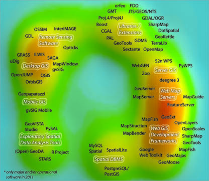
[[File:Projectsmap_v1_150dpi_grey.jpg]] | [[File:Projectsmap_v1_150dpi_grey.jpg]] | ||
Latest revision as of 13:13, 13 January 2012
- The general overview page: Open Source GIS Software
- The software list itself: FOSS4G Software List
Software that needs to be checked / was checked for inclusion:
Projects that need to be checked for the list:
- eventually:
- webdev: MS DeepZoom/DeepEarth
- database/DBMS: ---
- metadata: ---
- desktop GIS:
- ETL: Spatial Data Integrator (Talend) (not open source?)
- data/map server: ---
- libs: ---
- WMS Server: ---
- WFS Server: ---
- Image Analysis: OpenDragon (is not open source)
Decided not to be in the map:
- Desktop GIS: Kosmo, iGeoDesktop, Whitebox, Puzzle GIS, Kalypso, GearScape (based on OrbisGIS)
- DBMS: (1) CouchDB, (2) Ingres Spatial, (3) Hybernate Spatial, (4) MongoDB
- WMS server: Mapnik's Paleoserver, QGIS Mapserver, Constellation SDI (seems to be dead)
- WFS server: TinyOWS
- Web GIS Developer tools: Google GWT (no continuation of project), SLMapViewer (is for MapServer), MS DeepZoom/DeepEarth, OpenZoom (only for images), ModestMaps (there is not much traffic/activity)
- metadata: MDweb (Metadata Registry); GeoNetwork (Metadata Registry), CatMEdit (metadata desktop)
If you have suggestions on projects I missed, please drop me an email sstein[-at=]geo.uzh.ch
lasy update: Jan 13th, 2012 - stefan
